Advanced Along-Track Scanning Radiometer (AATSR)
Source:http://www.naturalsciences.be Source: http://mtp.jpl.nasa.gov Advanced Along-Track Scanning Radiometer (AATSR) is one of the Announcement of Opportunity (AO) instruments on board the European Space Agency (ESA) satellite ENVISAT. It is the most recent in a series of instruments designed primarily to measure Sea Surface Temperature (SST), following on from ATSR-1 and ATSR-2 on board ERS-1 and ERS-2. AATSR data have a resolution of 1 km at nadir, and are derived from measurements of reflected and emitted radiation taken at the following wavelengths: 0.55 µm, 0.66 µm, 0.87 µm, 1.6 µm, 3.7 µm, 11 µm and 12 µm. Special features of the AATSR instrument include its use of a conical scan to give a dual-view of the Earth's surface, on-board calibration targets and use of mechanical coolers to maintain the thermal environment necessary for optimal operation of the infrared detectors. AATSR coverage for the SMAPEx study area is summarised in the table below. AATSR data can be downloaded from ESA.
Mission
AATSR
Sensor
Advanced Along-Track Scanning Radiometer (AATSR)
Spacecraft
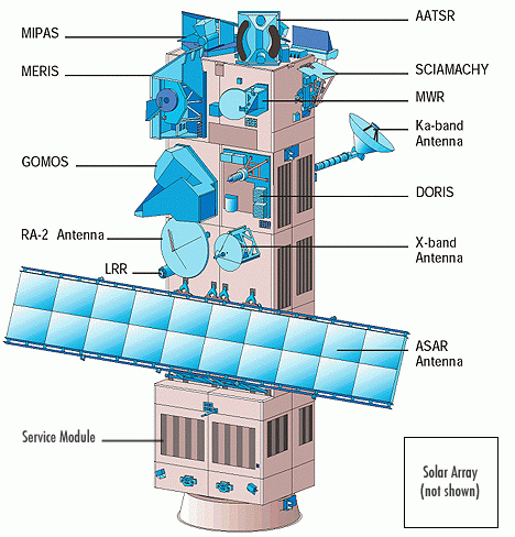
Envisat
Launch date
1st, Mar. 2002
Design life
3 years with a goal of 5 years
Orbit
Sun-synchronous polar orbit (SSO): Nominal reference orbit of mean altitude 800km, 35 days repeat cycle, 10:00am mean local solar time (MLST) descending node, 98.55°. inclination. [envisat.esa.int]
Spacecraft operations control centre
ESA
Accuracy
Sea surface temperature: <0.5K over 0.5 deg x 0.5 deg (lat/long) area with 80% cloud cover Land surface temperature: 0.1K (relative)
Swath (km)
Waveband
Spatial resolution (m)
IR ocean channels: 1km x 1km, Visible land channels: 1km x 1km
Temporal resolution
35 days repeat cycle
AATSR overpass time
The AATSR overpass times for the SMAPEx study area have been determined from a Fortran program based on the NORAD data, and are provided in the table below. Date and time are in UTC.
●=full AATSR coverage of airborne box; ○=partial AATSR coverage
●=concurrent; ●=non concurrent
Date (UTC)
AATSR overpass start time (UTC)
Duration (s) Flight Type
05/07/2010 ●0:01
48 ● Transect
06/07/2010 -
- Regional
Multi-angle07/07/2010
-
- Target YB
08/07/2010
-
- Regional
Multi-angle09/07/2010
●13:07
58 ●Target YA
10/07/2010
●0:18
64 ●Regional
●Multi-angle